
Keyword
Earth Science | Biosphere | Vegetation | Biomass
15 record(s)
Type of resources
Topics
Keywords
Contact for the resource
Provided by
Formats
Update frequencies
Status
draft
-

As part of the Pilbara Marine Conservation Partnership (PMCP), coral reef surveys of reef macroalgae species (including seagrasses) were undertaken between northern Ningaloo and the Dampier Archipelago. This dataset contains biomass estimates (g DW m-2 and g WW m-2) of macrophytes collected in shallow reef areas in the Pilbara region during two sampling trips: November 2013 and May 2014. Surveys were undertaken using using SCUBA at depths between 2-13m, with macroalgae and seagrasses identified to the lowest possible taxonomic level. The data include: * Macroalgae and seagrass diversity (0.25 square metre quadrats) * Macroalgae and seagrass species composition and biomass per quadrat (0.25 square metre) These data were collected to estimate macrophyte biomass in shallow reef areas across the Pilbara region in two contrasting seasons. These data are an output of the Pilbara Marine Conservation Partnership (PMCP) Coral Reef Health Theme.
-
Coral reef surveys of reef macroalgae species (including seagrasses) were undertaken between northern Ningaloo and the Dampier Archipelago. This dataset contains biomass estimates (g DW m-2 and g WW m-2) of macrophytes collected in shallow reef areas in the Pilbara region during two sampling trips: November 2013 and May 2014. Surveys were undertaken using using SCUBA at depths between 2-13m, with macroalgae and seagrasses identified to the lowest possible taxonomic level. The data include: * Macroalgae and seagrass diversity (0.25 square metre quadrats) * Macroalgae and seagrass species composition and biomass per quadrat (0.25 square metre) These data were collected to estimate macrophyte biomass in shallow reef areas across the Pilbara region in two contrasting seasons.
-
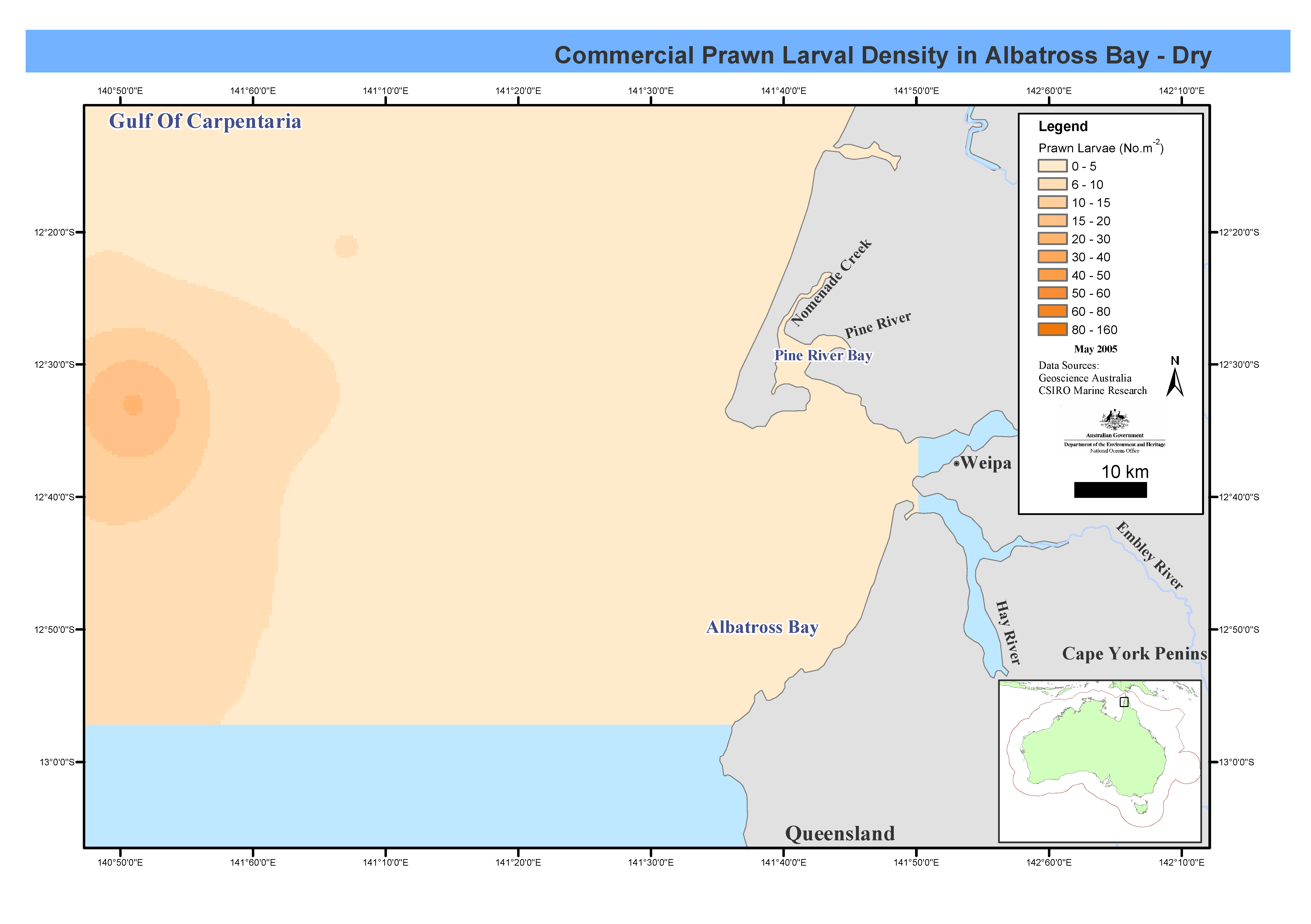
This mapset shows prawn larval distribution of commercial species pooled by species group and season for Albatross Bay. The map base data was produced by CMR stepped oblique bottom to surface plankton tows. Monthly cruises were carried out between March 1986 and April 1992, at twenty-one stations in Albatross Bay, Gulf of Carpentaria. Prawn larval densities were measured and salinity-temperature profiles taken. These maps have been produced by CSIRO for the National Oceans Office, as part of an ongoing commitment to natural resource planning and management through the 'National Marine Bioregionalisation' project.
-
This dataset contains data on species distributions, productivity, reproduction and growth of mangroves and saltmarshes from Jervis Bay, NSW. The data were obtained from a variety of surveys and measurement techniques between October 1988 and July 1991. Taxa identified comprised of about 130 vascular flora species, 15 of which are exotic. Species numbers range from 2 species in the mangroves to more than 80 in the fringe forest. Population structures of the 5 dominant species - Avicennia marina, Aegiceras corniculatum, Casuarina glauca, Sclerostegia arbuscula and Gahnia filum vary spatially. Temporal change in populations of Avicennia has occurred over time intervals of 20 years, the other species appear to have remained stable over the past 50 years. 13 maps on the mangrove and saltmarsh complexes have been prepared at a scale of 1:4000. The Jervis Bay mangroves and saltmarshes were compared with other locations around Batemans Bay and Port Hacking. NB - As the database has been lost, the only data still available are those published in the JERVIS BAY BASELINE STUDIES Final Report.
-
This dataset contains data on species distributions, productivity, reproduction and growth of mangroves and saltmarshes from Port Hacking, Botany Bay, NSW. The data were obtained from a variety of surveys and measurement techniques from two creeks between 1989 and 1991. The data were taken as a control site for similiar sampling in Jervis Bay. The data are part of the Jervis Bay Marine Ecological Study. NB - As the database has been lost, the only data still available are those published in the JERVIS BAY BASELINE STUDIES Final Report.
-
This dataset contains seagrass productivity and distribution data from Wagonga Inlet, adjacent to Narooma, NSW. The data were obtained between April and October 1991. The data were taken as a control site for similiar sampling in Jervis Bay. The data are part of the Jervis Bay Marine Ecological Study. NB - As the database has been lost, the only data still available are those published in the JERVIS BAY BASELINE STUDIES Final Report.
-
This dataset contains seagrass productivity and distribution data from Port Hacking, Botany Bay, NSW. The data were obtained between April and October 1991. The data were taken as a control site for similiar sampling in Jervis Bay. The data are part of the Jervis Bay Marine Ecological Study. NB - As the database has been lost, the only data still available are those published in the JERVIS BAY BASELINE STUDIES Final Report.
-
Seagrass biomass, density and morphometrics were measured at sites around Groote Eylandt and Albatross Bay in the Gulf of Carpentaria. Environmental data such as depth were also collected at a number of sites. Transect data was collected to give a qualitative assessment of these parameters.
-
This record describes data from the ATR-FTIR and Raman spectrometers collected on the Marine National Facility RV Investigator voyage IN2015_V01. This was a trial voyage for the RV Investigator departing Hobart on the 21st March and returning to Hobart on the 29th March, 2015. The PerkinElmer Spectrum 2 Attenuated Total Reflectance Fourier Transform Infrared (ATR-FTIR)Spectrometer (serial # 99683) on loan from PerkinElmer Australia. The instrument acquires infrared spectra of thin samples such as phytoplankton deposits on filters. FTIR spectra: 144 spectra from 48 samples from 6 sites Calibration of the PerkinElmer instrument performed by the company prior to the voyage. The BaySpec Agility Raman spectrometer with 1064 nm excitation laser and fibre probe optics (serial # P1480093) owned by Monash University. The instrument acquires Raman spectra of phytoplankton deposits. Raman spectra: 72 spectra from 12 samples from 2 sites Calibration of the Monash University instrument last performed 26 February 2015.
-
This map shows chlorophyll a concentrations in Albatross Bay, Gulf of Carpentaria. Phytoplankton pigment composition (chlorophyll a concentration) was measured in Albatross Bay, Gulf of Carpentaria, northern Australia. Four sites were sampled over six years between August 1986 and April 1992. In the last two years samples were taken at the bottom of the water column in addition to mid-depth. This map has been produced by CSIRO for the National Oceans Office, as part of an ongoing commitment to natural resource planning and management through the 'National Marine Bioregionalisation' project.